tlohde.commapping with leaflet
More from  tlohde

European Geological Open Data (Map And Data) From The European Geological Data Infrastructure (EGDI)
--
https://www.europe-geology.eu/data-tools/map-viewer/ <-- shared link to map viewer
--
#geology #geosciences #earthsciences #data #spatialdata #criticalminerals #mining #geothermal #netzero #groundwater #carboncapture #ccs #GIS #spatial #mapping #opendata #webmapping #mapportal #Europe #EGDI #framework #GSEU #resources #naturalresources #opendata #water #naturalresources #geomorphology #bathymetry #geophysics #topobathy #remotesensing #earthobservation #waterresources


Want to go somewhere this weekend, but not sure where?
Try following your shadow...or if you don't want to do that - have a look at where it would have taken you.
I made a thing, and wrote about it:
 and a slider title target speed (10 km/h). To the left is a table showing: location, sunrise, sunset, daylight duration, path length and route length. Below this is a map showing a smooth curve between a green point and a red point, with a wiggly route that roughly follows the smooth curve. At the bottom is another slider for changing start time and end times.")
Seeking recommendations for a #WebMapping tutorial / course?
Slightly at sea on where to start.
- My current JS skill level is _extreme novice_.
- I don't have access to ArcGIS.
- Comfortable with #QGIS [*] and the #python #geospatial ecosystem (#geopandas #xarray #rasterio and plotting with #matplotlib)
Suggestions welcome. TIA. 
* I have looked at the qgis2web plugin, but having some issues associated with my aged laptop (2012 mbp running Ubuntu) and a 'Wayland session'.
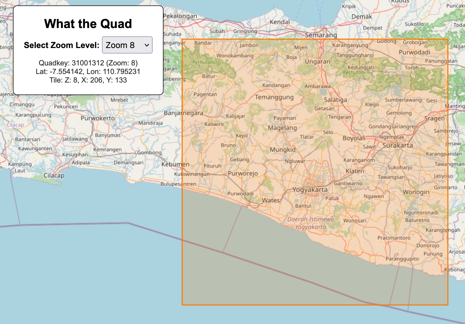
Perhaps I am the only one who ever needs to quickly look up the z/x/y or quadkey for a map tile, but I made this thing a while ago to do just that. Ehm, enjoy, I guess? https://mvexel.github.io/whatthequad/ #gis #maps #webmapping
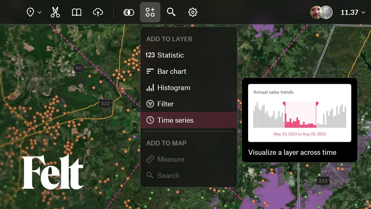
We've introduced a lot of exciting updates with Felt 3.0!  Explore our revamped user interface and discover all the new features.
  https://youtu.be/99roNtqD4GQ
Colorado Wetland Inventory Mapping Tool
--
https://csurams.maps.arcgis.com/apps/webappviewer/index.html?id=a8e43760cb934a5084e89e46922580cc <-- web map access
--
#GIS #spatial #mapping #wetlands #fen #bog #marsh #colorado #USA #webmapping #opendata #ColoradoWetlandsInventoryMappingTool #CWIMT #hydrology #water #biota #ecosystems #habitat #riparian #NWI #CHNP #playa #conservation #stressors


Australia’s Support To Pacific Surges As China Focuses On ‘Friendly’ States, [Lowy Institute Pacific ] Aid Map Shows
--
https://www.theguardian.com/australia-news/2023/oct/31/australias-support-to-pacific-surges-as-china-focuses-on-friendly-states-aid-map-shows <-- shared media article
--
https://pacificaidmap.lowyinstitute.org/ <-- Lowy Institute Pacific Aid Map
--
[as someone who has spent time on many of these places, islands, this was of particular interest as a way of indicating geopolitics, applied finance, etc]
#GIS #spatial #mapping #geopolitics #aid #SouthPacific #aid #PacificIslands #Pacific #finance #aidevelopment #PacificAid #pacifica #LowyInstitute #PacificAidMap #internationalbusiness #internationalaffairs #spatialanalysis #budget #money #support #foreignaid #transparency #donors #opendata #webmapping #Australia #China #influence #development #developmentfinance
@LowyInstitute


Soar | The New Atlas
--
https://soar.earth/maps <-- SOAR home page
--
[sharing the details of this web page / service does not constitute an endorsement]
“A digital atlas for all the world's maps and imagery ##
Soar is the world's largest online atlas, and the home of maps on the internet.
[Their] platform allows anyone in the world to view, upload, discover, and interact with an enormous library of high quality maps and images. We’re bringing together every map, satellite, and drone image that has ever existed, or will ever exist, in one place…”
#GIS #spatial #mapping #webmapping #global #resource #remotesensing #clearinghouse #online #onlinemapping #spatialdata #map #satellite #drone #imagery #spatialanalysis
@Soar_Earth


We just put up a new map showing campaign contributions to NYC candidates in next week's elections.
Tomorrow at the University of Guanajuato, within the "Engineering Week" event, I will be presenting, as part of the Official QGIS Mexico User Group  , the #GIS
  of the Government of #Guadalajara
  done in the last two years of work (Only the new developments)
Using #FOSS geospatial 
#QGIS #Potree #PostGIS #Geoserver #Leaflet #OpenDroneMap #WebODM #WhiteboxTools #Lastools #CloudCompare #GeoSAM
For #LiDAR #webmapping #drones #photogrammetry #cadastral #survey #AI #mobility
Global Freshwater Quality Database (GEMStat) [UN]
--
https://gemstat.org/ <-- GEMStat home page
--
“The Global Freshwater Quality Database GEMStat provides scientifically-sound data and information on the state and trend of global inland water quality. As operational part of the GEMS/Water Programme of the United Nations Environment Programme (UNEP), GEMStat is hosted by the GEMS/Water Data Centre (GWDC) within the International Centre for Water Resources and Global Change (ICWRGC) in Koblenz, Germany…”
#GIS #spatial #mapping #dataportal #opendata #global #waterresources #waterquality #monitoring #surfacewater #freshwater #watersecurity #GEMStat #UNEP #GWDC #ICWRGC #ecosystem #wetland #groundwater #river #lake #reservoir #nutrients #pollutants #TSS #parameters #webmapping #UnitedNations #UN


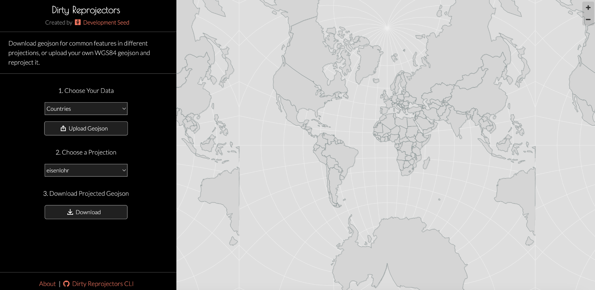
Someone on Twitter recently shared and tagged us about our Dirty Reprojectors tool. We always love it when some of our oldie but goodie projects get re-found.
Thought ya'll would like it too. Check it out here: https://github.com/developmentseed/dirty-reprojectors
We've added photo locations maps to our main web page & our galleries (in progress). Means that you can easily browse spatially or, for a photo, see where the subject is located.
Be good if you could have a poke around and give us any comments - P&L


Just joined this wild new federated world, time for an #introduction
I'm a landscape archaeologist by training, with specializations in #medieval and #postmedieval #archaeology in #Greece and #GIS . I love maps so much that I became a GIS librarian!
Other interests (in no particular order):
#programming
#python
#remotesensing
#satellites
#spacearchaeology
#webmapping
#opendata
#openaccess
#foss
#libraries
#metadata
More videos from yesterday's #qgisopenday include a deep dive into the new @felt plugin: Using #QGIS and #Felt for #Sharing and #Collaboration
https://youtube.com/live/wd6LCNcOMz4
And here is the full list of sessions if you are just catching up after #foss4g
Filtered dataviz in a parent popup - YouTube
https://www.youtube.com/watch?v=aGJnScdkEtE
Huge thread about the history of vector tiles from Nathaniel Kelso! It's the 10th anniversary of a landmark blog post by @migurski that defined much of the modern landscape of #VectorTileCartography: https://mstdn.party/@kelsoscorner/110029394759495359 #cartography #WebMapping #WebMaps #maps


 Greg Cocks